
 has issued critical weather warnings across both the northern and southern extremes of the country.)
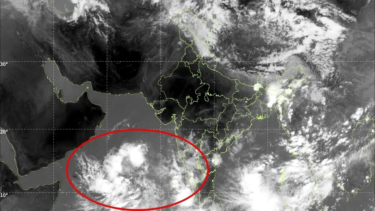
New Delhi, May 25, 2026: The India Meteorological Department (IMD) has issued critical weather warnings across both the northern and southern extremes of the country. Advanced meteorological imaging from the INSAT-3DS satellite reveals a dramatic visual dichotomy over the subcontinent: a massive, spiraling Western Disturbance is moving across the Himalayas, while deep convective cloud bands are gathering rapidly over the Arabian Sea. These highly active atmospheric conditions have prompted meteorologists to issue crucial yellow alerts across multiple states as significant pre-monsoon and early monsoon weather systems collide.
1. The Northern Frontier: Heavy Surge Over the Western Himalayas
In the northern reaches of the country, the latest INSAT-3DS thermal infrared imagery shows a prominent, dense spiral of cold cloud tops curling directly over the Western Himalayas. This classic signature indicates a highly active Western Disturbance—a low-pressure weather system originating from the Mediterranean region—colliding directly with the intense, rising heat of the Indian pre-monsoon summer.
The satellite data reveals bright white cloud bands over Jammu & Kashmir, Himachal Pradesh, and Uttarakhand. These highly developed vertical structures mean that towering thunderclouds have formed rapidly, bringing an immediate threat of heavy localized rainfall, lightning strikes, and localized hailstorms. The IMD has formalized yellow alerts for these regions, warning residents of sudden downpours and gusty winds reaching speeds of 40 to 50 km/h. Travelers and authorities in high-altitude zones are being urged to exercise caution due to the risk of sudden landslips, reduced visibility, and flash runoff in mountainous streams.
2. The Southern Front: Monsoon Onset Over Kerala and Karnataka
While the northern mountains grapple with turbulent winds, an entirely different—yet equally powerful—atmospheric shift is taking place over southern India. The same satellite tracking shows immense clusters of deep convective clouds building with exceptional speed across the south-east Arabian Sea, positioning themselves directly over Kerala and the Lakshadweep archipelago.
This thick buildup of equatorial moisture signifies an aggressive strengthening of the Southwest Monsoon, signaling its imminent arrival on the mainland. In response to this heavy cloud surge, weather officials have locked in a persistent five-day rainfall forecast for the region.
-
Kerala: A yellow alert dominates 11 districts across the state, including heavy-risk pockets like Pathanamthitta, Alappuzha, Kottayam, Idukki, Ernakulam, and Thrissur. The sudden spike in water levels has already forced authorities to open the barrage shutters of the Bhoothathankettu dam, keeping communities along the Periyar River on high alert.
-
Karnataka: Further north, a parallel yellow alert has been extended to Bengaluru and several interior districts, including Tumakuru, Hassan, and Chitradurga. The capital city has already faced severe pre-monsoon lashings, resulting in localized power disruptions, uprooted trees, and waterlogged commuter corridors.
3. Contrast in the Plains: Severe Heatwaves Remain
Paradoxically, the dramatic cloud surges on the northern and southern coastlines have left a vast gap across the central plains of India. Even as parts of the country prepare for immediate rain, the IMD has concurrently maintained a yellow alert of a very different nature for Delhi, Punjab, and Haryana.
In these regions, the absence of incoming moisture has allowed a severe heatwave to lock into place. Daytime temperatures are projected to soar between 44°C and 46°C over the coming days, offering a harsh reminder of the typical pre-monsoon atmospheric squeeze. Emergency management departments across all affected states—whether facing the threat of heavy thunder-showers or battling extreme thermal highs—have advised citizens to track real-time radar updates, secure loose outdoor structures, and minimize non-essential travel during peak alert windows.